
GPR and GIS are two of our most reliable tools for gaining clarity in historical, unmarked, and/or poorly documented burial areas.
Together and separately, GPR and GIS allow us to create highly detailed survey outputs for municipalities, churches, private cemeteries, tribal lands, and preservation organizations. Get a feel for what’s possible via the cemetery mapping case studies below, and get in touch to learn more about our process and solutions.
CLIENT: Venus Cemetery Association, Venus, Texas CEMETERY SIZE: 7 acres / 1,728 interments PROJECT DURATION: February 2025 – May 2025
While the cemetery had done its best to maintain records over time, the lack of digital mapping led to confusion and inefficiencies. Staff recognized that without a modern mapping solution, future generations would face even greater challenges in maintaining accuracy and accessibility.
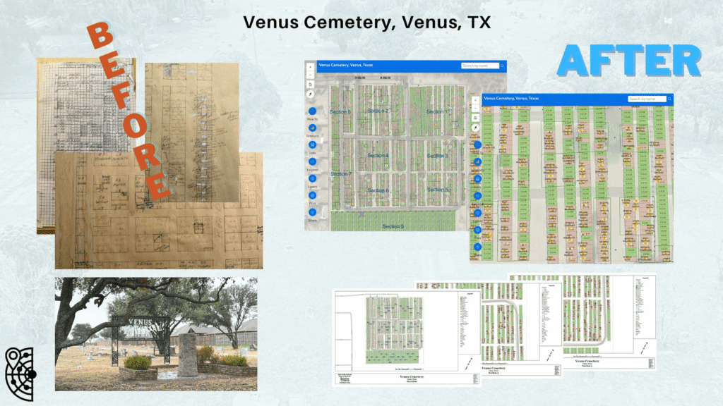
Our team conducted a thorough site assessment using GPR, GPS, and GIS technology to create an accurate, digital representation of the cemetery that could be easily maintained going forward.
ViaVista Mapping produced a user-friendly, searchable digital map that replaced outdated records and provided a permanent, accurate foundation for future management and preservation efforts.
Each ViaVista Mapping project is tailored to the cemetery’s unique needs, combining technology, accuracy, and compassion to deliver lasting value to communities.
CLIENT: Grace Episcopal Church Cemetery, Elkridge, MD
CEMETERY SIZE: 1 acre / 350 interments
PROJECT DURATION: July 2023 – August 2023
Some of the cemetery’s records had burned in a fire. The remaining paper maps were decades old and inconsistent with burial records. Cemetery caretakers strongly suspected unmarked burials.
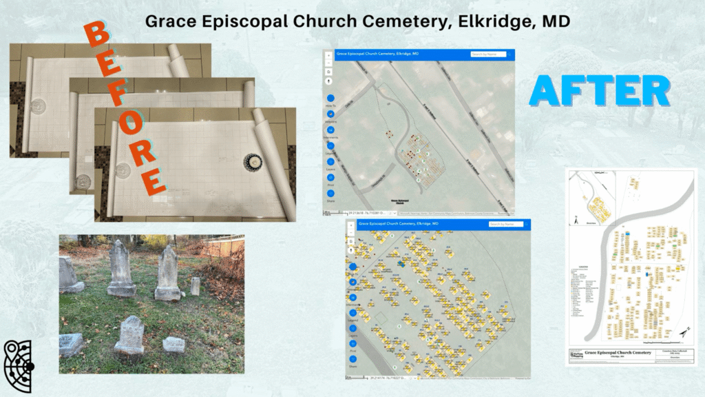
ViaVista Mapping conducted a full Ground Penetrating Radar (GPR) scan to detect unmarked burials and verify the location of marked burials, followed by a GPS survey of all visible headstones, relevant cemetery features, and lot boundaries. We then cross-referenced GPR cemetery mapping survey results with historical records to ensure every resting place was documented.
ViaVista Mapping produced a user-friendly, searchable digital map that replaced outdated records and provided a permanent, accurate foundation for future management and preservation efforts.
Accurate digital mapping bridges the gap between historical preservation and modern management, allowing cemeteries to honor their past while planning effectively for the future.
CLIENT: City of Cripple Creek - Mt. Pisgah Cemetery, Colorado
CEMETERY SIZE: 42 acres / 4,089 interments
PROJECT DURATION: June 2025 – August 2025
Record-keeping had become increasingly difficult over the years. The cemetery relied on outdated hard-copy maps with hand-drawn notations that no longer reflected the true layout of the grounds. This made it difficult to manage burials, plot sales, and public inquiries efficiently.
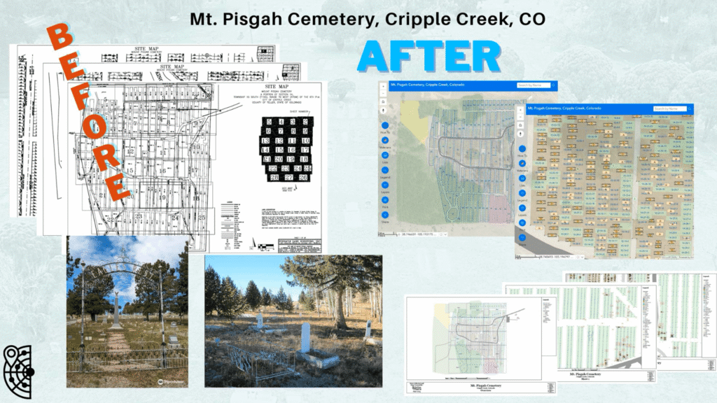
ViaVista Mapping conducted a full Ground Penetrating Radar (GPR) scan to detect unmarked burials and verify the location of marked burials, followed by a GPS survey of all visible headstones, relevant cemetery features, and lot boundaries. The data was carefully cross-referenced with historical records to ensure every resting place was documented.
Using the GPR cemetery project results, we delivered a cloud-based mapping solution integrated with ArcGIS, giving staff and authorized users real-time access to cemetery data. The result is a single source of truth for record-keeping and public information.
Accurate digital mapping bridges the gap between historical preservation and modern management, allowing cemeteries to honor their past while planning effectively for the future.
CLIENT: City of Buckeye - Hazelton Memorial Cemetery, Arizona
CEMETERY SIZE: 15.5 acres / 5,950 interments
PROJECT DURATION: Initial mapping February 2022 – May 2022; ongoing updates
The cemetery’s existing paper maps were decades old and inconsistent with burial records, creating challenges for both staff and visitors. Families often struggled to locate loved ones, and staff spent valuable time cross-referencing handwritten notes and spreadsheets.
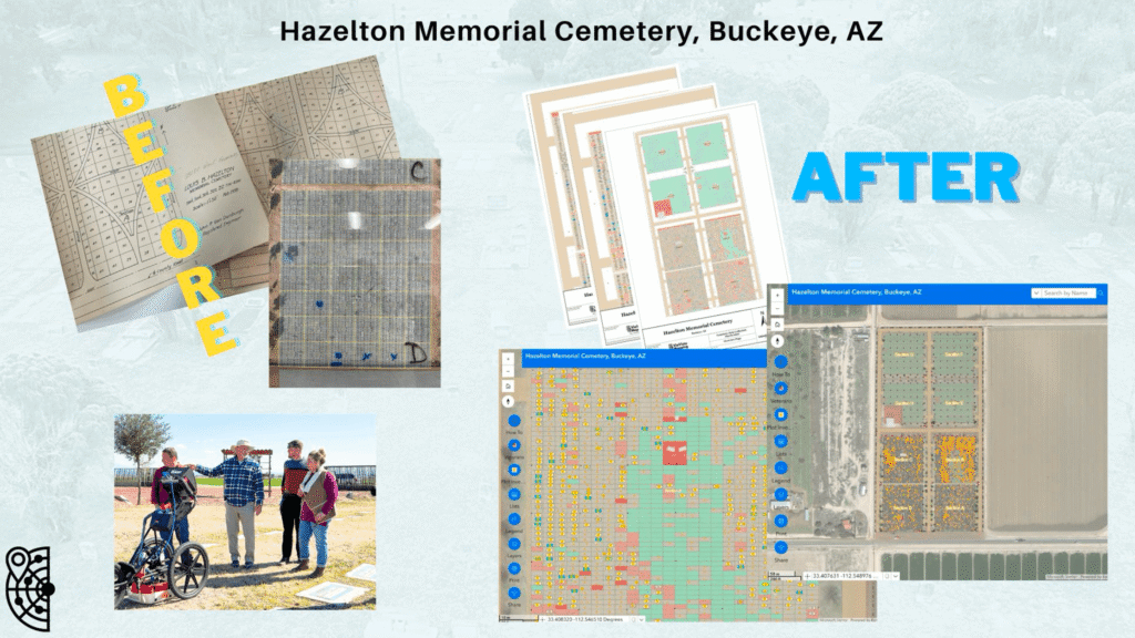
Collaborating closely with the cemetery’s staff, ViaVista Mapping combined modern field data collection with archival research to produce a precise and visually clear map. We also provided staff training to ensure long-term success and confident use of the new tools.
ViaVista Mapping produced a user-friendly, searchable digital map that replaced outdated records and provided a permanent, accurate foundation for future management and preservation efforts.
Modern mapping technology has preserved the cemetery’s history while ensuring operational efficiency for the future. Staff now have a reliable and easy-to-use system to support both internal use and public engagement.