
Cemetery Mapping Services
Benefits of Cemetery Mapping with GPR
Cemetery mapping services offer essential benefits for today’s cemetery caretakers. As the cost of real estate continues to rise and available space becomes more limited, having accurate and up-to-date burial plot maps is more important than ever. At the same time, an aging population is driving increased demand for burial sites—posing a growing challenge for cemetery staff with finite space. Without detailed documentation, such as a precise burial map, future burials, land development, or other use of the property may be restricted.
Many historic cemeteries lack reliable burial records as well, and often, no accurate plot map exists. What digital cemetery mapping does is use advanced ground-penetrating radar (GPR), which can detect the location of unmarked graves—even in cases where remains or caskets have deteriorated over time. By marking each site and recording GPS coordinates, we create an accurate and up-to-date cemetery plot layout.
Even better, our clients receive a permanent digital record, and we provide convenient cloud-based access to a digital cemetery map, along with electronic data files for long-term archive needs.
Expert Digital Cemetery Mapping Services
Ground Penetrating Radar
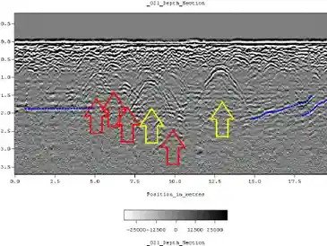
Ground-penetrating radar (GPR) is a geophysical method that uses radar pulses to image the subsurface. It is a non-intrusive method of surveying the sub-surface to investigate underground anomalies. This nondestructive method uses electromagnetic radiation in the microwave band (UHF/VHF frequencies) of the radio spectrum and detects the reflected signals from subsurface structures.
Ground Penetrating Radar is perfect for finding unmarked graves, mass burial sites, covered burial stones, and underground utilities.
Using a GSSI Utility Scan, GPR scanning is conducted in relevant areas of the cemetery, including inside coping, to verify marked burials, discover unmarked graves, and locate relevant subsurface features. The GPR scan will include open areas within the boundaries of the site and will be managed, from start to completion, by a Certified GPR Site Supervisor
GPS Data Collection
GPS stands for global positioning system, and it uses signals from satellites to pinpoint a location on the Earth’s surface. When used by skilled professionals and combined with results of GPR cemetery mapping, GPS provides surveying and mapping data of the highest accuracy.
On-site GPS collection of cemetery data makes possible the generation of a true-to-life, as-built burial plot map that improves cemetery records and supports long-term cemetery management.
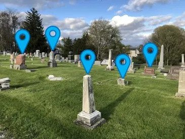
We use a high-accuracy GNSS receiver coupled with Trimble collection software and Esri’s ArcGIS applications to record precise coordinates of relevant cemetery elements. We collect GPS points for physical features in the cemetery, including headstones, unmarked burials discovered with GPR scanning, coping areas, fences, monuments, and structures, and we capture images of headstones and other pertinent features in the cemetery.
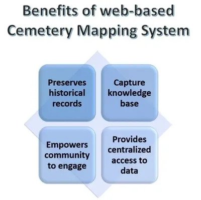
Web-based Cemetery Burial Plot Maps
A geographic information system (GIS) is a cemetery mapping framework for gathering, managing, and analyzing data that is referenced to locations on the earth. The data set includes tabular attribute data that provides additional details about individual spatial features. Our cemetery mapping process combines GPS data, attribute information, and images to create a dynamic map of the cemetery.
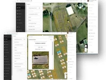
Using GPS and photographic data collected on-site, we create an interactive WebMap on the Esri ArcGIS platform. The final WebMap is searchable by the name of the deceased, includes locations of any marked/unmarked graves and cemetery landmarks, and includes images of individual headstones. We can also help optimize your cemetery space by evaluating open areas and identifying any potentially available burial plots for future burials.
Creating a Burial Map Takes 3 Steps
Field data collection (GPR cemetery mapping, GPS cemetery mapping)
GIS post-processing (blend field data with relevant existing cemetery records on ArcGIS)
Finished burial plot maps provided to client via WebMap and large-format printable pdf.