GPS Cemetery Mapping
GPS Cemetery Mapping Services for Data-Enriched Cemetery Plot Maps
“Our GPS cemetery mapping services provide cemetery caretakers with exact locations of each burial site. Additionally, we use high-accuracy GPS data collection equipment to record precise locations and create reliable cemetery plot maps. Moreover, our services are available throughout the United States for various organizations and landowners.”
We understand your cemetery mapping needs. When creating a cemetery plot map, it’s important to understand the placement of each grave and cemetery feature accurately. In order to accomplish this, we use GPS cemetery data collection devices to generate the necessary data for creating these maps. Additionally, our grave mapping services provide detailed cemetery mapping information, showing marked and unmarked burials within a lot. As a result, ViaVista Mapping creates accurate burial plot maps for easy visualization and access to information about the cemetery.

How GPS Cemetery Mapping Helps With Marking the Graves
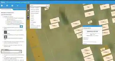
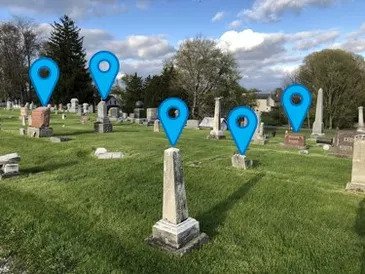
A GPS cemetery mapping company utilizes the Global Positioning System to survey and navigate places with the use of satellite signals. In various industries, this nondestructive and safe system serves numerous purposes. Specifically in cemeteries, GPS helps to accurately record the locations of graves and cemetery features. Subsequently, the data is transferred to the Esri ArcGIS platform to develop a searchable burial plot map.
Our skilled cemetery mapping technicians document every headstone, capture detailed attribute information for each grave, and take an image of the headstone. We use this GPS data collection to generate a precise cemetery plot map that is interactive and helps increase engagement with stakeholders.
Mapping a Cemetery: Dynamic and Searchable Plot Maps