
Cemetery Ground Penetrating Radar
Ground Penetrating Radar Services for Cemeteries
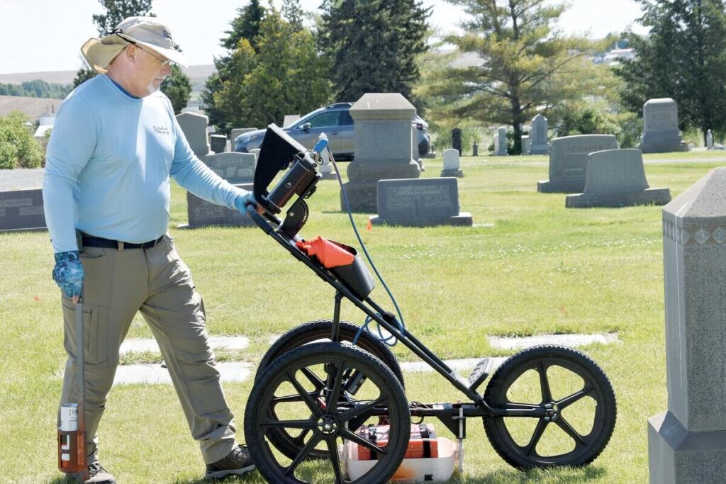
Cemetery ground penetrating radar (GPR) is a mapping tool we use to survey burial grounds and create accurate cemetery maps. Many cemeteries have unmarked graves, lost graves, and old burials, along with the easily identified more recent burials. Our ground penetrating radar services locate known (marked), unmarked, and lost graves in cemeteries without disturbing these sensitive sites.
How Cemetery Ground Penetrating Radar Works
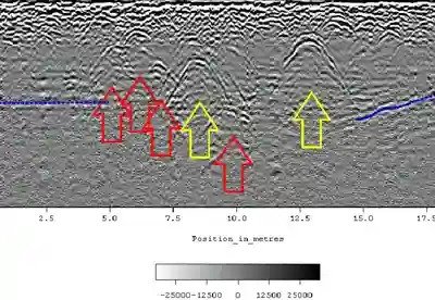
Ground penetrating radar for cemeteries is a non-destructive means of identifying subsurface features on cemetery grounds without the need for drilling, probing, or digging. It works by emitting high-frequency pulses of radio waves into the ground using a GPR transmitter and antenna. The pulses have a specific depth penetration rate depending on the soil’s dielectric properties. Buried objects or distinct contacts between different earth materials reflect the transmitted energy, which is then received by the antenna. The digital control unit displays the resulting soil profile as bands based on the reflected waves.
Our cemetery ground penetrating radar services can detect disturbed soil caused by:
- Wooden and/or metal caskets
- Voids in the earth with little to no surviving skeletal remains
- Ceremonial burial objects
- Historical objects
- Vaults
- Improperly positioned graves
- An unmarked grave
- Underground utilities
- Etc.
With our training and experience, we are capable of interpreting this data to identify unmarked graves and sub-surface anomalies.

The Purpose of GPR Mapping
GPR cemetery mapping helps explore cemeteries and locate unmarked graves, providing essential data to create an accurate burial plot map and plan for the cemetery’s future. By carefully marking unidentified graves, you can preserve history and improve your recordkeeping.
Our innovative mapping system integrates the data collected during ground penetrating radar scans into the Esri ArcGIS platform to create burial plot maps with detailed information, including the location of unmarked burials. Proper cemetery records are essential to help people searching for graves access information and understand the exact layout of the burial plots, and thus these maps are imperative to have.
ViaVista Mapping provides a visually appealing cemetery plot maps known for their precision and quality. Even better, stakeholders can access the dynamic, searchable burial plot map on any connected device or computer through a weblink, greatly improving stakeholder engagement.
Inquire About Our GPR Services
Our GPR services offer a safe, noninvasive way to gather meaningful data. As the industry-standard method for cemetery analysis, it provides the critical insights needed to identify any marked or unmarked grave, as well as create a precise and reliable cemetery map.
Cemetery Ground Penetrating Radar FAQs
Ground penetrating radar identifies changes in soil composition caused by burial activity. When the radar signals encounter disturbed soil, voids, or buried materials like caskets or vaults, the reflected waves create a clear visual profile that helps us pinpoint unmarked or lost graves.
Yes. Even when wooden coffins have deteriorated over time, GPR can still identify the disturbed soil left behind by the burial process or detect voids that remain in the ground.
Often, yes. GPR can detect objects like burial vaults, foundations, markers, and other subsurface features like archaeological or historical artifacts present in cemetery grounds.
GPR is one of the best tools available for historic cemeteries and sites. Because GPR is completely non-invasive, you can identify old or unrecorded graves and understand burial patterns without disturbing the ground.
Yes, it can help identify undisturbed areas within a cemetery, confirming where there is available space for new burials.
Completely. The process uses radar pulses sent into the ground and requires no excavation or drilling.
Once data is collected, we process it and integrate it into Esri ArcGIS mapping software to create detailed, digital burial maps. These maps include the locations of marked and unmarked graves and can be securely viewed or shared online by cemetery staff and stakeholders.
Start by assessing your records. If burial maps are incomplete, boundaries are unclear, or there are questions about unmarked graves, you should request a GPR survey.