
Ground Penetrating Radar (GPR) has become critical for locating unmarked graves and preserving the integrity of burial sites. This non-invasive technology allows cemetery managers, historians, and communities to rediscover forgotten plots, verify burial locations, and protect sacred ground from unintentional disturbance. At ViaVista, we use ground penetrating radar to find unmarked graves and subsurface anomalies with precision.
Why Detecting Unmarked Graves Matters
Unmarked graves exist in cemeteries across North America for many reasons. Wooden markers deteriorate. Stone monuments sink or get removed. Historical records are lost. Without proper documentation, burial sites risk being disturbed during landscaping, construction, or expansion projects.
Locating unmarked graves gained widespread attention following announcements by Indigenous communities about potential unmarked burials at former residential school sites across Canada. These discoveries highlighted GPR’s capabilities and the importance of respectful investigation. This same technology that brings acknowledgment to painful histories serves cemeteries in their mission to preserve and protect all burial grounds.
How Ground Penetrating Radar (GPR) Works
Ground Penetrating Radar operates by transmitting electromagnetic pulses into the soil. As these waves travel downward, they encounter different materials, such as soil, rock, metal, and voids, and areas where the earth has been disturbed. Each material reflects the radar signal back to the surface at different rates and intensities, creating a unique signature.
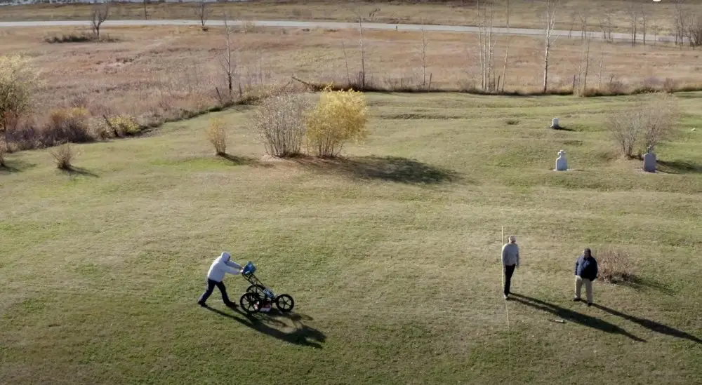
The GPR unit captures these reflected signals and translates them into visual data that trained technicians can interpret. During a cemetery survey, technicians systematically walk the GPR equipment across the site in a grid pattern, collecting data that reveals what lies beneath the surface without disturbing a single inch of ground.
Different soil conditions affect GPR performance, too. Sandy or dry soils typically provide excellent penetration and clear results, while clay-heavy or saturated ground can limit depth and resolution. Weather, vegetation, and terrain also influence the survey process, which is why experienced operators understand how to adapt their approach to each unique site.
How to Find an Unmarked Grave in a Cemetery with GPR
To find unmarked graves with Ground-Penetrating Radar, the process starts by gathering whatever information exists: approximate burial dates, family records, cemetery documentation, or oral histories. Even fragmentary information helps narrow the search area.
Once the search area is identified, a GPR survey scans the ground to detect subtle changes in the soil’s structure. When a grave is dug, those layers are cut through, mixed, and replaced. The refilled soil settles differently, holding moisture and density in ways that don’t match the surrounding ground. GPR picks up those contrasts, allowing technicians to spot the exact outlines of burial shafts even when there’s no visible trace on the surface.
Finding unmarked graves with high-tech solutions like GPR allows cemeteries to create accurate cemetery plot maps of burial locations. This prevents accidental disturbance and helps families locate ancestors whose graves were forgotten. The technology is especially valuable in historical cemeteries where records are incomplete or markers have disappeared.
What GPR Can and Cannot Do
There are capabilities and limitations of ground penetrating radar when used to detect unmarked graves. GPR identifies anomalies, or areas where subsurface conditions differ from the surrounding soil. These anomalies may indicate graves, but the technology cannot definitively confirm the presence of human remains without further investigation.
A GPR survey can reveal patterns consistent with burial, like rectangular disturbances of appropriate dimensions, aligned in rows, at expected depths. These factors allow experienced technicians to assess the likelihood that an anomaly represents a grave rather than a natural feature, buried debris, or other subsurface variation.
Confirmation, however, requires additional work. Historical photographs, death records, burial registers, and oral histories can corroborate GPR findings. In cases requiring absolute verification, soil coring or archaeological excavation may be necessary, though communities often prefer to avoid invasive investigation when strong circumstantial evidence already exists.
Common Misconceptions About Ground Penetrating Radar
One frequent misunderstanding is that GPR can “see” through the ground like an X-ray. In reality, GPR data requires interpretation by trained professionals who understand radar signatures, soil science, and burial practices. What appears on a GPR readout is not a photograph but a representation of reflected electromagnetic energy.
Another misconception stems from media reports about unmarked grave discoveries. When communities announce that GPR has detected a specific number of potential graves, some people mistakenly believe that remains have been physically recovered and counted. GPR identifies anomalies consistent with burials, as mentioned previously, but physical confirmation is a separate process that may or may not follow.
Conversely, skeptics sometimes dismiss GPR findings by pointing out that the technology cannot guarantee every anomaly is a grave. While true, this criticism overlooks the fact that experienced operators can distinguish between patterns typical of burials and those created by rocks, roots, utility lines, or other subsurface features. The combination of GPR data with historical context, site characteristics, and professional expertise yields highly reliable results.
Applications of GPR in Cemeteries
Cemeteries rely on ground penetrating radar unmarked graves services for numerous practical purposes beyond simply locating unmarked burials. For example:
- GPR surveys help cemetery managers create comprehensive digital maps that document every plot, including those without visible markers.
- Historical preservation projects may incorporate GPR to identify boundaries of old burial grounds that may have expanded informally over time or where sections have been forgotten as communities grew and changed. This information protects burial sites from development and ensures they receive appropriate care and recognition.
- Cemeteries planning infrastructure improvements can use GPR surveys to verify that work will not disturb burial sites.
- Cemeteries can recover and restore markers covered by soil accumulation, deliberately buried during leveling operations, or toppled by weather or vandalism.
Our Mapping Process
Step 1 – Field Data Collection
A certified GPR site supervisor scans the cemetery, including inside coping, to confirm marked burials, locate unmarked graves, and identify any subsurface features. Alongside the GPR work, GPS coordinates are collected for surface landmarks such as headstones, coping, fences, and walkways. Each monument and feature is photographed to document the site visually and support the mapping process.
Step 2 – GIS Post-Processing
The GPS data, gravestone images, and GPR findings are combined inside the Esri ArcGIS platform. Each burial location is tagged with attribute data (names, inscriptions, and any available record details) to create an accurate, searchable map. Historical records and satellite imagery are also reviewed and layered into the geodatabase to strengthen accuracy and visual clarity.
Step 3 – Deliverables
The completed interactive WebMap is shared through a secure link and is accessible from any device. Clients also receive large-format PDF maps for archival and planning use. The final results bring together ground data, imagery, and records to create a precise, noninvasive record of the cemetery layout.
Frequently Asked Questions
Can GPR confirm the presence of human remains?
GPR detects soil disturbances and anomalies consistent with burials but cannot definitively confirm human remains without additional investigation. When anomalies match expected burial patterns and are corroborated by historical records, the evidence strongly indicates graves are present.
How accurate is GPR in finding unmarked graves?
When operated by experienced technicians in suitable soil conditions, GPR is highly accurate at identifying burial-related disturbances. Accuracy depends on soil type, burial depth, site conditions, and burial age. Sandy or dry soils provide the best results.
What types of anomalies does GPR detect besides graves?
GPR identifies rocks, tree roots, utility lines, construction debris, voids, and natural variations in soil composition. Experienced operators distinguish between these anomalies and those consistent with burials by analyzing pattern, depth, orientation, size, and context.
How is GPR used in cemeteries specifically?
Cemeteries use GPR to locate unmarked graves, find buried headstones, verify plot locations before maintenance work, create accurate digital maps, establish boundaries of historic burial grounds, and assist families searching for ancestral graves.
Does GPR damage or disturb the site?
No, Ground Penetrating Radar is completely non-invasive. The equipment is rolled or carried across the surface without digging, drilling, or ground penetration.
Ready to learn more about our ground-penetrating radar services? Explore our website or contact us today for a free quote.