
Cemetery mapping has come a long way from earlier computer-printed maps cobbled together from digitized ledgers and manual data entry. Today, GPS, GIS, and Ground Penetrating Radar work together to produce a modern cemetery map accurate to the centimeter. Here, we trace that evolution, break down how each technology contributes, and explain why precision mapping is now one of the most important investments a cemetery can make.
Traditional Cemetery Mapping vs. Modern Methods
Traditional mapping had charm but lacked reliability. Hand-drawn maps and ledger books served cemeteries for centuries, but human errors shifted plot numbers, or boundaries mysteriously redrew themselves. For older sections, matching records to ground reality was guesswork. These challenges compound over time, turning daily operations into nightmares and historic sites into legal risks.
Do cemeteries have maps of graves? Yes, most do, but the quality varies dramatically from hand-drawn sketches to modern GPS-enabled digital systems. Traditional methods often leave critical questions unanswered: Is that plot truly empty? Where exactly is so-and-so buried? These uncertainties create operational headaches and emotional distress for families.
The Evolution of Cemetery Mapping Technology
The shift to digital started modestly. Basic databases digitized ledgers without fixing inaccuracies. CAD cleaned up drawings, providing clearer visual representations, GPS surveying added real-world coordinates, and GIS technology layered in topography, utilities, and features to create a richer, more comprehensive view of cemetery grounds.
The evolution of cemetery mapping technology reached a critical turning point with the adoption of Ground Penetrating Radar. This non-invasive technology transformed cemetery documentation from guesswork into data-driven precision. ViaVista Mapping enhances this progression with high-accuracy GPS to capture headstones, pathways, boundaries, and markers, forming the backbone for easily updated, authoritative cemetery records that serve both operational needs and historical preservation.
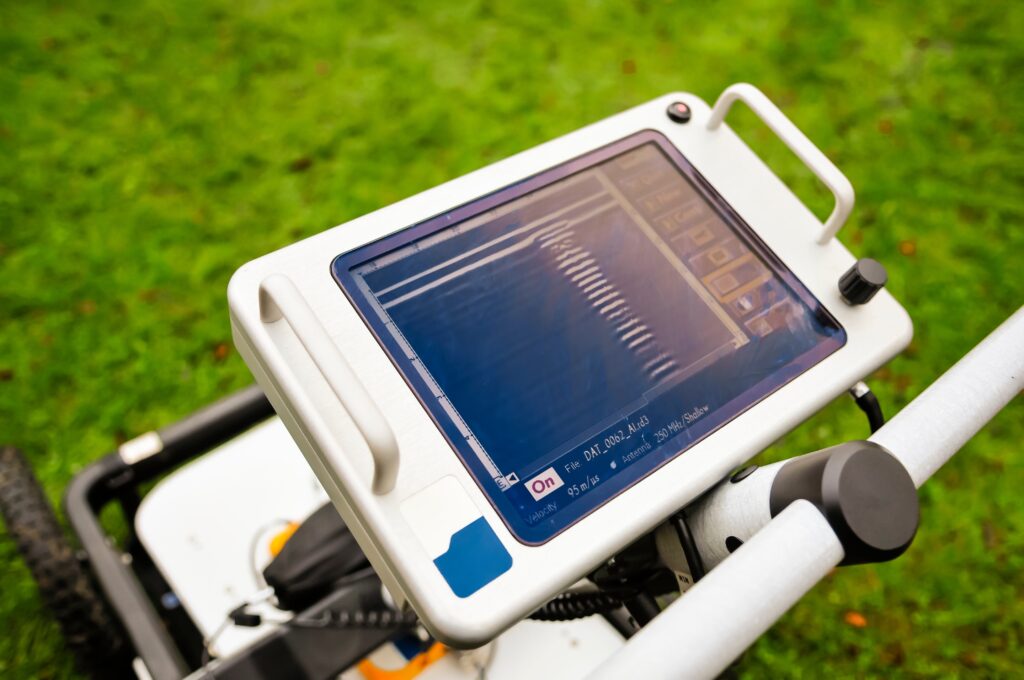
How GPR Works in Cemetery Mapping
Ground penetrating radar for cemeteries is a non-destructive means of identifying subsurface features on cemetery grounds without the need for drilling, probing, or digging. It works by emitting high-frequency pulses of radio waves into the ground using a GPR transmitter and antenna. The pulses have a specific depth penetration rate depending on the soil’s dielectric properties. Buried objects or distinct contacts between different earth materials reflect the transmitted energy, which is then received by the antenna. The digital control unit displays the resulting soil profile as bands based on the reflected waves.
Cemetery ground penetrating radar services can detect disturbed soil caused by wooden and/or metal caskets, voids in the earth with little to no surviving skeletal remains, ceremonial burial objects, historical objects, vaults, improperly positioned graves, unmarked graves, underground utilities, and more.
With proper training and experience, professionals interpret this data to identify unmarked graves and sub-surface anomalies, giving cemetery managers unprecedented clarity about their grounds.
GPR and Precise Cemetery Plot Mapping
Precise cemetery plot mapping represents the gold standard in cemetery management, combining GPR validation with GPS accuracy to create definitive burial records. GPR confirms occupied versus available space, eliminating the guesswork that plagued traditional methods. This technology excels at locating unmarked graves and previously undocumented burials, discoveries that prevent plot conflicts and the nightmare scenario of double-selling burial spaces. When integrated with GPS and GIS systems, GPR data enhances geospatial accuracy to centimeter-level precision.
Benefits of GPR-Based Modern Cemetery Maps
The advantages of implementing a modern cemetery map system extend far beyond simple record-keeping. Increased accuracy and confidence in burial records translates directly into operational efficiency, while protection against liability becomes built-in when you can definitively prove plot boundaries and occupancy. Historic cemeteries also gain new life through preservation efforts backed by accurate data.
Families experience immediate benefits, too. They locate graves quickly without frustration, groundskeepers work without fear of disturbances, and genealogy enthusiasts access reliable data for uncovering ancestral connections. Better long-term planning and expansion management become possible when you truly understand your available space. Digital integration with cemetery management systems streamlines everything from plot sales to maintenance scheduling, cutting administrative time on inquiries while improving service quality.
Overcoming Common Challenges
Of course, challenges exist even in today’s era of cemetery mapping. Paper records in older cemeteries often contain contradictions, missing information, or references to landmarks that no longer exist. Soil conditions and environmental factors affect GPR readings.
As such, professional technicians become essential for accurate data interpretation. Raw GPR data appear as abstract waves and bands requiring expert analysis to distinguish true burials from tree roots or other subsurface features. Companies like ViaVista Mapping combine GPR data with historical records, GPS coordinates, and field observations to deliver reliable mapping outcomes that account for site-specific challenges.
The Future of Cemetery Mapping with GPR
The future of cemetery mapping technology is promising. Cloud-based integration will make GPR data accessible in real time, whether staff are working in the field or families are searching from home. 3D subsurface modeling may allow entire cemetery layouts to be visualized in unprecedented detail, and ongoing improvements in detection depth and clarity will push scanning capabilities even further.
The technology is ever-evolving, but if you’re ready to move your cemetery beyond outdated records and the risks that come with them now, a professional mapping assessment is where to start. ViaVista Mapping combines GPR, GPS, and GIS to build you a modern cemetery map grounded in verified, subsurface-confirmed data. Contact ViaVista Mapping today to get started.
Frequently Asked Questions
How long does a modern cemetery mapping project take?
Project timelines vary depending on cemetery size and site conditions. Small cemeteries can typically be mapped within a few days, while larger or more complex sites, like those with dense vegetation, irregular terrain, or layered historical records, may take several weeks or months.
Can a historical cemetery with few surviving records still be mapped using modern technology?
Yes, and this is where modern mapping technology proves most valuable. GPR can detect unmarked graves, burial vaults, and subsurface features even when paper records are incomplete or missing entirely. Combined with archival research, GPS surveying, and GIS integration, it becomes possible to reconstruct lost cemetery records and create a reliable, modern map where essentially none existed before.