
Cemetery mapping news: If you’re driving past the Brandon Lutheran Cemetery this week, you might see a strange man with strange equipment walking the grounds in the blazing heat.
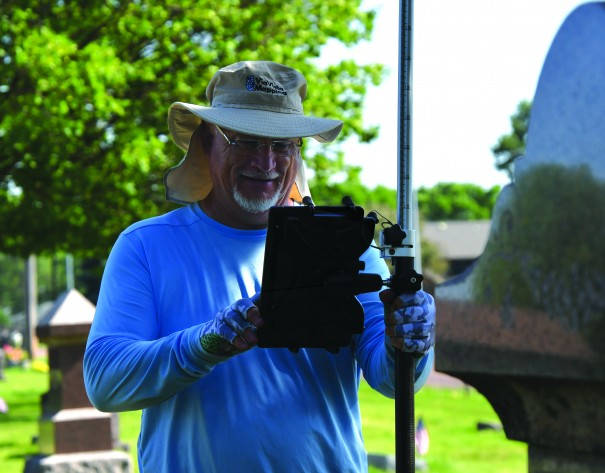
This man is Scott Field, owner of ViaVista Mapping, who is digitally mapping all of the marked and unmarked graves at the Brandon cemetery located along Sioux Boulevard. Field uses ground-penetrating radars (GPR) and GPS satellite systems to map both what’s above ground for what people can see, and what’s below ground where unknown, unmarked graves lie.
“A lot of people don’t know about it and they don’t know they need us until they need us,” Field said. “We usually get a call after somebody’s gone out to try to bury somebody and they hit something and there’s a burial there.”
“There’s also a lot of cemeteries out there that they’re finally figuring out that one person apparently knows where everybody is at and that person is 85 years old and he’s in the hospital and they’re scared to death, that’s when we’ll get a call,” he said.
Glenn Thiele, the cemetery sexton, was visiting the cemetery last summer with his daughter who studies genealogy. As the two walked through the graves, they noticed that there were many unmarked graves they wanted to identify and locate.
“We were trying to figure out where things are at, how the cemetery was laid out and what the natural progression was,” he said. “After we started looking at headstones, we realized some of them don’t have stones and some of them are not in the church records at all.”
Thiele consulted Jerry Dahlin, the former sexton, for the cemetery records and quickly found out that the records kept over the centuries were not sufficiently preserving the history of the graves.
“I wanted to figure out what is actually out here and others had mentioned in the past that they wanted to find out as well,” Thiele said. “We are trying to figure out if there is somebody in the ones that are marked, for the ones that don’t have stones, is there something there? We can probe the ground to see if there’s something down there, but that’s not always real accurate.”
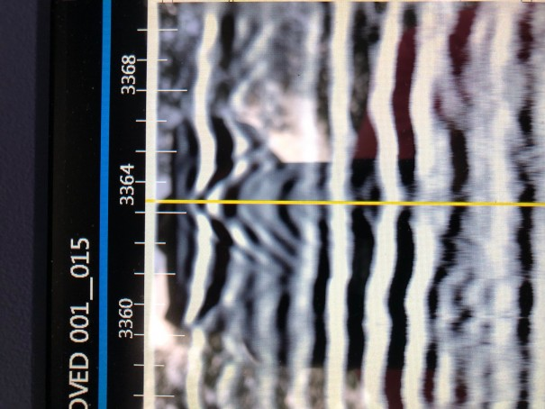
Thiele enlisted Field’s help and now, Field will continue his work at the cemetery throughout this week mapping the graves. He uses satellites to map the above-ground view where the head and footstones lie and a GPR to scan underground and highlight abnormalities, which indicate a grave.
The data Field collects is then transferred into a digital, interactive map of the cemetery that can be accessed on ViaVista’s website. An overhead view of the cemetery shows every grave, a photo of the headstone, who is buried there, whether the plot is open or if there is an unmarked body.
“I will go to the center of every burial I’ve found and take a GPS point and take a picture of the person that’s in that carrier,” Field said. “For the unmarked graves, I’ll take a GPS point saying ‘hey, this is an unmarked burial,’ Now all that information will get put in the cloud and post-processing will take that and make a map.”
Field said he just completed a job in Victoria, Texas where he located a mass burial for enslaved people using his GPR technology. The cemetery owners knew the burial site existed but didn’t know the exact location and asked ViaVista to help.
Thiele said a QR code will be available at the cemetery entrance for people to scan and look up the exact location and plot number of their loved ones. This feature and Brandon’s cemetery map will be ready to use on ViaVista’s website in September.
Not only can Field’s technology track the current grave sites, but it can also mark the plot of land west of the cemetery that Thiele said will be for new graves in the coming generations. Since Field will have all the data collected on the area, once new graves are put into the plots, Field can add their information to the website without remapping the area.
In 2018, Field and his wife Christina retired from their corporate jobs and sold their house and all their belongings to buy an RV and travel the country. Six months later, Field got bored and they bought ViaVista Mapping and started booking cemeteries along their journey. They have done three cemeteries in Howard and one in Colman.
“I’ve been traveling all across the United States and mapping cemeteries. We go to little towns like this with amazing people. You meet your Lynn and your Bubba and your Jerry. You’re helping them and that’s what we like to do is help people. We’re providing a good service,” Field said.
Christina said the on site field collection will be completed by Thursday.
Dahlin noted the importance of the preservation of the cemetery’s history and the growing population of Brandon as why they decided to have the cemetery digitally mapped.
“We’ve got to be organized,” he said. “We’ve got 11,000 people now and a lot of them will probably be buried here and this is where they’re going to call home. … A cemetery is for the people that come back to the community and want to find loved ones so that’s why we’re doing this.”
Cemetery mapping news from the Brandon Valley Journal
Contact us today find out more about our services and for a free quote.